Open data - Download the Knowledge base
You are free to download the data of this Knowledge base.
To do this you must be an authenticated user: log in or sign in now.
All the data are licensed as Creative Common CC-BY 4.0.
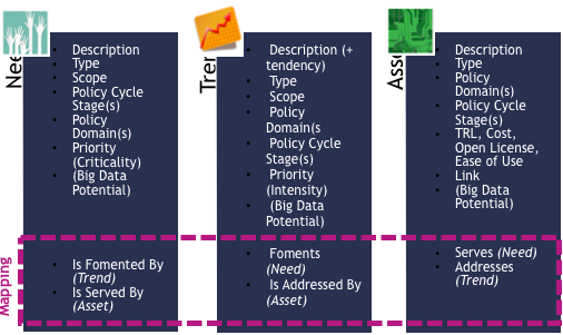
The Big Policy Canvas Knowledge Base is a state-of-the-art, online and dynamic repository that functions as an accumulator uniting all the knowledge produced during the project. It is structured along the three dimensions of needs, trends and assets and furthermore offers a mapping among them by defining how they are interconnected and how they influence each other.
Are you aware of an asset that can help enrich the BPC KB? Share it with us and be named contributors to our work.
The Big Policy Canvas Knowledge Base is a state-of-the-art, online and dynamic repository that functions as an accumulator uniting all the knowledge produced during the project. It is structured along the three dimensions of needs, trends and assets and furthermore offers a mapping among them by defining how they are interconnected and how they influence each other.
Accordingly, the Knowledge Base comprises all current and emerging needs and trends as well as the technological and methodological assets serving and addressing them respectively. Every element identified in the three dimensions is defined according to its type, scope, priority, and the policy domains and policy cycle stages in which it applies. A list of criteria, namely namely the type of need, trend or asset, the priority, the Big data potential, as well as the type of item itself enable the user to filter and navigate through the Knowledge Base contents.
The Knowledge Base targets to support the uptake and reuse of solutions that hold the potential to advance policy making processes, leading towards next-generation policy making.
Read the article about the Knowledge Base in the blog and know more about how we have identified and analysed the trends and how we have assessed the Big Data Potential.
Galileo is the European Union's Global Satellite Navigation System (GNSS). Sometimes called the ’European GPS‘, Galileo provides accurate positioning and timing information. Galileo is a programme under civilian control and its data can be used for a broad range of applications. It is autonomous but also interoperable with existing satellite navigation systems. At the moment, the Galileo constellation consists of 24 satellites.
EUMETSAT is the European operational satellite agency for monitoring weather, climate and the environment with the purpose of supplying reliable and accurate weather and climate-related satellite data, images and products – 24 hours a day, 365 days a year – to the National Meteorological Services of the EU Member States and other users worldwide.
EUMETSAT provides data, products and support services to the Copernicus information services and user communities, with a focus on marine, atmosphere and climate.
OPEN ARTFISH stands for Open Approaches, Rules and Techniques for Fisheries statistical monitoring. It is a generic database which estimates the total catch and value by species for sampling schemes of small-scale fisheries.
The toolkit comprises a generic database (OPEN ARTFISH) and a mobile phone application. The toolkit’s primary objective is to facilitate the implementation of cost-effective and sustainable routine data collection, storage and analysis of data, using the appropriate statistical procedure
The United States Department of Commerce and the Bureau of Economic Analysis in partnership with the European Commission's DG CONNECT and Eurostat have established a Transatlantic Open Data Partnership focused on economic data. The eu.us.opendata R library is the direct result of this collaborative effort, enabling easy access to comparable datasets from the Eurostat API and BEA API. Built following a Linked Open Data design, the R library taps into the Bureau of Economic Analysis' API and the Eurostat API to make comparable data accessible.
European Union Open Data Portal (EU ODP) gives you access to open data published by EU institutions and bodies. All the data you can find via this catalogue are free to use and reuse for commercial or non-commercial purposes.
Platform for exploring and downloading Employment Ontario open data
Nowcasting is a forecasting methodology that is becoming increasingly popular in economics. The use case considers the potential use of Νowcasting in the context of economic policy setting and sets the potential value of an extended use of Νowcasting against different contexts.
This use case covers the methods that can assist policymakers throughout all stages of the policy cycle. It explains the sources for these data and how the outputs can be used to gain. understanding of stakeholders’ and citizen’s opinions on policies and strategies
The Smart Fire Department could be one aspect of a Smart Government scenario. Intelligently networked objects such as smoke detectors, smartphones, surveillance cameras and drones can support the work of the fire department thus leading to tracking behaviour, enhanced situational awareness, sensor-driven decision analytics, process optimisation, optimised resource consumption, complex autonomous systems.
Sensors perfect the transport infrastructures by reporting automatically about its utilisation and current condition. Sensor-generated information about the stress on roads, tracks, canals, bridges and tunnels helps civil engineering authorities to better estimate the condition of the infrastructure. They recognise and repair damages in the transport infrastructure in order to ensure an optimal traffic flow. This is supplemented by indications from citizens via apps.
You are free to download the data of this Knowledge base.
To do this you must be an authenticated user: log in or sign in now.
All the data are licensed as Creative Common CC-BY 4.0.


This website reflects the views only of the Consortium, and the Commission cannot be held responsible for any use which may be made of the information contained herein. The editorial content of this site is distributed under a Creative Commons License, Attribution-ShareAlike 4.0 International (CC BY-SA 4.0) except where otherwise specified.