Open data - Download the Knowledge base
You are free to download the data of this Knowledge base.
To do this you must be an authenticated user: log in or sign in now.
All the data are licensed as Creative Common CC-BY 4.0.
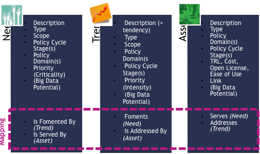
The Big Policy Canvas Knowledge Base is a state-of-the-art, online and dynamic repository that functions as an accumulator uniting all the knowledge produced during the project. It is structured along the three dimensions of needs, trends and assets and furthermore offers a mapping among them by defining how they are interconnected and how they influence each other.
Are you aware of an asset that can help enrich the BPC KB? Share it with us and be named contributors to our work.
The Big Policy Canvas Knowledge Base is a state-of-the-art, online and dynamic repository that functions as an accumulator uniting all the knowledge produced during the project. It is structured along the three dimensions of needs, trends and assets and furthermore offers a mapping among them by defining how they are interconnected and how they influence each other.
Accordingly, the Knowledge Base comprises all current and emerging needs and trends as well as the technological and methodological assets serving and addressing them respectively. Every element identified in the three dimensions is defined according to its type, scope, priority, and the policy domains and policy cycle stages in which it applies. A list of criteria, namely namely the type of need, trend or asset, the priority, the Big data potential, as well as the type of item itself enable the user to filter and navigate through the Knowledge Base contents.
The Knowledge Base targets to support the uptake and reuse of solutions that hold the potential to advance policy making processes, leading towards next-generation policy making.
Read the article about the Knowledge Base in the blog and know more about how we have identified and analysed the trends and how we have assessed the Big Data Potential.
Cool Farm Tool water metrics enable farmers quickly and easily account for their crops’ water needs and gain insight into better practice.
The tool combines just user inputs with global data sets for crop, soil and climate data, to provide crop water estimates.
The software helps farmers to plan, monitor and analyse all activities on their farm like tillage, planting, crop protection, fertilization, irrigation or harvesting.
OPEN ARTFISH stands for Open Approaches, Rules and Techniques for Fisheries statistical monitoring. It is a generic database which estimates the total catch and value by species for sampling schemes of small-scale fisheries.
The toolkit comprises a generic database (OPEN ARTFISH) and a mobile phone application. The toolkit’s primary objective is to facilitate the implementation of cost-effective and sustainable routine data collection, storage and analysis of data, using the appropriate statistical procedure
FishStatJ is a Java-based desktop application which provides users with access to a variety of fishery statistical datasets. It consists of a main application and several workspaces that include the datasets. FishStatJ key features are: (1) statistical datasets browsing, data mining, charting and reporting; (2) filtering, grouping and aggregation through hierarchical dimensions
Official Service partner for Microsoft and NATO.The main aim is that the customer should be able to concentrate on the important things, without having to waste time on or worry about maintaining their systems. That has led to the development of numerous tools that offer immeasurable help with performance optimization, data security, data imaging and with the recovery lost data.
ALERTS (beta), the Automated Land change Evaluation, Reporting and Tracking System, beta edition, is a web-based prototype application for near real-time global land use and land cover change detection
Manual that includes information about Open Policy Making as well as the tools and techniques policy makers can use to create more open and user led policy
A Cloud-based video platform to analyse traffic movements. The German part of the project by Fraunhofer HHS aims to develop low-complexity, real-time algorithms for analysis of large-scale visual data. In consideration of increasingly growing cities in European industrial countries it becomes more and more important that the traffic situation has to be optimised. The service tries to solve this issue by analysing data streams to discover free park spaces for
Saudi Arabia, currently offers MASAR a real-time tracking system, to create more space between the streets of Mecca and Medina, the most holy cities of ISLAM (Shia and Suni) during the days of Hadji. For this reason, the house AL Saud has created a Smart city research centre for Crowd Control (one of the biggest of the world). The researchers developed MASAR a tracking platform for guests and citizens to help them by planning their root towards the Kaaba
You are free to download the data of this Knowledge base.
To do this you must be an authenticated user: log in or sign in now.
All the data are licensed as Creative Common CC-BY 4.0.


This website reflects the views only of the Consortium, and the Commission cannot be held responsible for any use which may be made of the information contained herein. The editorial content of this site is distributed under a Creative Commons License, Attribution-ShareAlike 4.0 International (CC BY-SA 4.0) except where otherwise specified.